

The place you are seeing on the picture is 'Suweolbong'. 'Suweolbong' is UNESCO designated Geo-park. There are 9 UNESCO Geo-parks in jeju island: the names are Suweolbong Tuff ring, Sanbangsan Lava dome, Yongmeri coast, Jusangjeli columnar-Jointed lava, Seokwipo formation, Chenjuyeon waterfall, Sungsan ilchulbong, Manjanggul lava Tube, Mt Halla.
Today Let's have some glimps of Suwelbong Tuff Ring.

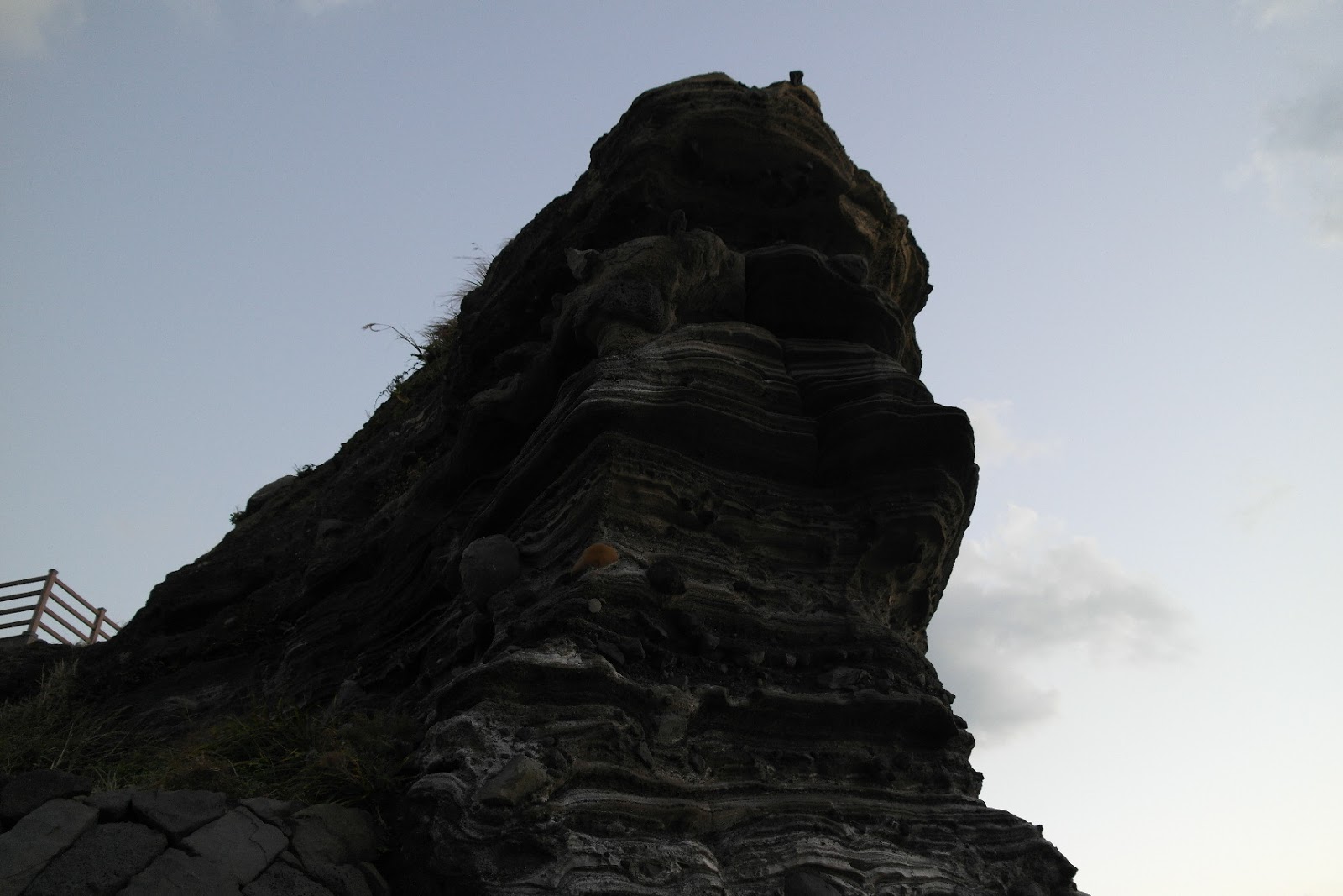
'Sewelbong Tuff Ring' is locate in western part of Jeju island. Around 18,000 years ago in this place hot ascending magma explosively interacted with groundwater, then depositional structures and a tuff ring composed of volcanic ash had been accumulated to build up a magnificient cliff. The outcrops of the Suweolbong Tuff Ring are so continuous that individual tuff layers can be correlated bed-by-bed.
Suweolbong is well -known as a text book of research of process of volcano in world wide.

Volcanic ash spread around Suweolbong became rich soil for plants compared with hard lava, which provided ground of life for humans in the Neolithic Period. By those reasons many relics of the Neolithic age have been found in this area.
You probably can see caves under the cliff and water is flowing through holes. There are small caves and big ones and each of caves contain som water on the bottom. People in this area think this water is holy water.
Some times they come to this water to give a ritual to the god of sea.

Giving a ritual to the god of sea can be a kind of shamanism. Even though people living in modern society might laugh at it, I think it's a beautiful custom which we should keep it.

Some parts of cliff have been eroded a lot and it makes some holy spiritual anmal shape. What do you think this rock looks like? May be Dragon?
Once you down on the Suweolbong, there is a tracking course to Chakwi-do which is lava volcanic islets.
It takes around 20-~30min. One thing you can't miss is that the contrast between the color of cliff and lava rocks on the shore. Lot's of black pentagon or heksagon lava roks you can see on the way. It is nice cool walking seeing all the amazing volcanic process. But you have to be careful for something. There are some sea farm near the coast line and it says 'keep out' in Korean. If you can't read Korean sign and just come into there without notice, you might get trouble with local peole. Well, even though you do, they don't hurt you^^/

When you walk down on the path you will see the excavations by Japanese military. It was probably used as arsonal during world war 2. Jeju was last defending line of Japan in those times. There are more than 500 Japanese military excavations around jeju island.

It's quite interesting to see spring waters coming out through the rocks. We call the water 'Yong chen su'. 90% of jeju island is covered by lava rocks and soil, so when it rains it just penetrateds into the ground and after time goes by it comes out near shores. That's why lots of villages are on shores in Jeju island.

There is a legend for the water: Once upon a time there a brother and a sister. The brother name was 'Nokgo' and the sister name was 'Suweol'. They climbed the cliff looing for the medicinal herb 'Ogalpi' to cure her mother. By mistake, the sister 'Suweol' was falling down. When her brother heard her scream, he went up on the cliff but she alreday fell down and died. He started to cry, and cry. Since that this cliff has been called 'Suweol-bong' and this water got name of 'the tears of Nokgo'.

I couln't resist to be taken a picture of. This is self - taking picture.

This is 'Chakwi-do' with sun set.

If you want more information click here. http://www.jejuweekly.com/news/
No comments:
Post a Comment